In the last year especially, I've been fascinated with Google Earth. The resolution, while far from "sharp," has improved to the point where one can zoom down and travel not just on "street scenes," but on any lonely trail in the back-country. I've taken virtual trips up and down a lot of the (mostly desert) trails that I'm curious about-- where does that path go? In my wandering days I turned around on some of the dirt trails I took before I made it the full distance, and I've "extended" some of those trips on G.E. to get a sense of what the rest of those trails look like. I've also "gone up" trails I meant to take, but never got around to taking. In one such virtual roam I even stumbled onto Manson's last desert hideout! (Interesting photos posted.)
One of these pixel-powered trips up a powerline trail above Lake Mohave even inspired a paragraph added to my collection of "Nevada Roundscape" observations...
Here's the image:"My eyes can't read the desert; they underestimate its span, and the great arcs increase the illusion. You climb gradually, many miles up a slope, and when you finally look back, a way-out low ridge you passed lower on the arc appears to be almost the same distance away as a dark hill you went toward for miles after passing the butte, and a pale ridge far beyond where you started to climb seems but a short stroll from both, and somehow you've climbed two thousand feet, and the view makes no sense. "
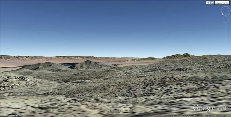
You can see a small ridge and a small hill that appear just to the right of the ridge at the center of the snapshot (the ones noted above), and they appear to be pretty close to each other. And you can see the "pale ridge" beyond. There are fairly major spans between these landmarks, yet the open space "compresses" the view.
This all seems fundamentally "wrong" somehow-- you know, our assimilation into the screen and all that-- but it has been interesting.